Project Maps
The Steering Group made the decision to use Ordnance Survey Vector Maps early on. They had sought advice from the Business and Spatial Solutions Department within Meath County Council. The information on these maps is quite up to date (less than 10 years old). They show townlands with field layouts largely as they are now except for any development or changes that have taken place in the last 10 years.
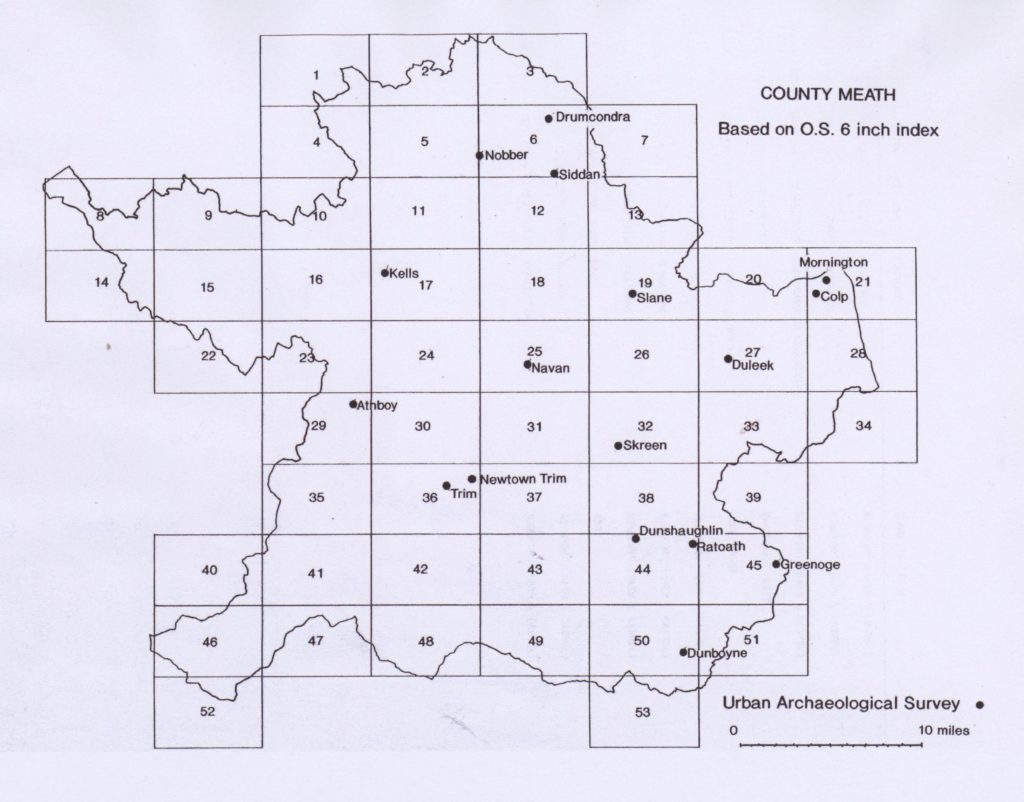
The county is divided into 53 of these grid vector maps. These are based on the Ordnance Survey 6 inch maps. [see Grid Map image of county Meath]. These maps are a cornerstone of the project. Each vector map came as a huge AO sized sheet, the size of an average kitchen table. On each vector map there could be up to 30 townlands.
Meath townlands vary greatly in size. The smaller townland can have 10-15 fields and a larger townland can have 100+ fields. The average townland has 30-40 fields. Most volunteers became quite familiar with these maps and could tell by number which map they were working on.
It was decided for the smooth running of the project that it would be a good idea to break the volunteers up into teams based on their map area. Most vector maps had one or two voluntary team leaders. These team leaders were given master copies of the map they were taking responsibility for.
Each team leader worked with a group of local volunteers in their area. A system of one person per townland was most common except in the case of a very large townland where several people needed to help.
The fields in each townland were numbered on the map – starting at number one for the first field in each townland in the top left corner. The fields were then numbered left to right, north to south until all the fields in the townland were numbered. The project photocopied the large AO sized grid maps and cut them up into smaller more manageable sized maps. Typically, a volunteer got a map showing the townland they were working on and a small bit of the surrounding area to help them get their bearings. Of course, some townlands cross the boundary of one or more vector sheets. This made life a little more complicated. Maps were specially made for these townlands and supplied to the relevant volunteers. This was quite a time consuming process.
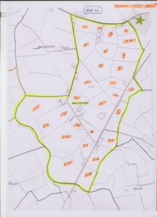
This is an example of a numbered townland map that a volunteer used to gather field names in this townland. This is Ballyclare townland on Map 41 near Longwood. It can be seen that the fields within the townland are numbered left to right, north to south until every field has a number. The townland boundary is clearly marked. The volunteer used this small map for their work, it shows the complete townland and a small amount of the surrounding area to help people get their bearings. This is quite a small townland so it fit easily onto an A4 sheet, many larger townlands had much bigger maps.
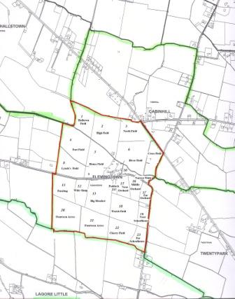
Map of Flemingtown townland, near Ratoath with the fields numbered and the field names marked in. Many of the field names for this townland were sourced from a historic townland map (Map with field names by Tony Darby).