The Meath Field Names Group is a voluntary group established in May 2008. This project is to record and publish the ‘Field Names’ of County Meath along with their history, features, name origin and folklore. The project is guided by an elected Steering Group along with a network of local volunteers. The project is strongly backed by Meath IFA, Meath Archaeological & Historical Society and Meath County Council Library Services. This project was supported by Meath Partnership, FBD Trust, the Heritage Council, the Trim Heritage Centre, business and private sponsors.
Due to changing farming and ownership patterns in rural Meath, the need to record the field names, folklore and features of our fields has become a matter of urgency. Much of the information is being carried in folk memory and is at risk because of the diminishing population of farmers and rural dwellers. Developments such as motorways, field amalgamations and modern farming practices are also bringing huge changes to the rural landscape of Meath. Old field names and valuable local history is easily lost with all this change process. The County of Meath has always been renowned for its rich heritage and history.
From early 2010 until 2013 the project worked on gathering field names and associated information in townlands all around the County with the help of several hundred volunteers. The information gathered was the inputted onto a database. This enabled the project to write up some of the main findings.
Meath Field Names Project launched it’s book ‘The Field Names of County Meath’ in June 2013. Information on the origins of the project; the project findings; volunteer experiences of doing survey work, a variety of townland maps; articles by contributors with specialist expertise and a vast range of photographs of Meath are all presented in this publication. For details on where to get the book, see the ‘news’ section of this wesite.
The project continues to gather field names for Meath townlands not already surveyed and welcomes contact from people who would like to help with this work. The project has also been working on making all the field names and associated information available through online mapping. The interactive mapping was launched on this website in June 2014 and is being constantly improved upon. Click on the red ‘interactive map’ icon to access it.
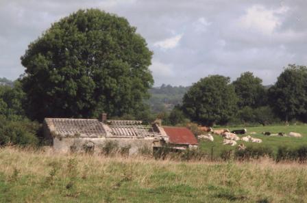
- Ruins of the Grove House with large deciduous trees and contented fattening cattle at Farranalcock, Carlanstown. Paddy Harten was the last person to live in this house, he lived here until approximately 40 years ago. Before him, Phil Reilly, a herd on O’Reilly’s estate lived here. (Photo by Matthew Lynch)

- Forge made gate painted red, stone piers and stone walls at Ballymacad, Oldcastle. Note the blocked up sheep gap to the right of the gate. (photo by Michael Gammell)

- Meath Field Names Project launched a book titled ‘The Field Names of County Meath’ in June 2013. Information on the origins of the project; the project findings; volunteer experiences of doing survey work, a variety of townland maps; articles by contributors with specialist expertise and a vast range of photographs of Meath are all presented here. For full details on where the book can be purchased see the ‘news’ section on this site.
This project has been co-financed by Meath Partnership through the Irish Department of Environment, Community & Local Government ‘Rural Development Programme Ireland 2007-2013’ and through the European Agricultural Fund for Rural Development: Europe investing in rural areas.

This project has also received funding from the FBD Trust and from the Heritage Council.