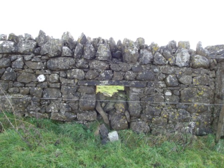
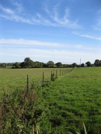
Sheep Passes, sheep walks and sheep gaps

These terms all describe the same thing – an opening in a stone wall that allows sheep to pass or move from one field to another without allowing cattle through. From our survey to date, their presence in Meath seems to be limited to fields in the greater Oldcastle area.
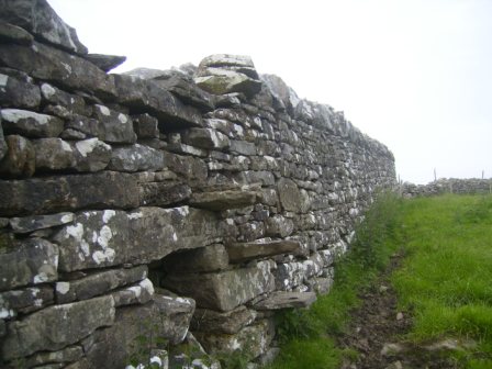
Sheep gaps built into the stone wall, partially filled in to the left and right of this field gate at Ballymacad, Oldcastle (photo by Michael Gammell)
Sheep gap (partially filled in) built into the stone wall in field in Ballymacad townland near Oldcastle. (photo by Michael Gammell).

Double ditches

Double banks are quite common features in Meath fields, but double ditches are a much more unusual feature. A double ditch is where there are two ditches very close together with a bank in the centre. Only 30-40 fields have been identified in the survey with a double ditch. The bank up the middle is certainly wide enough for a person to walk on and in the past may have been wide enough for a person on horseback or a horse and cart. There are different theories on why a double ditch exists. Some people believe that some of the double ditches represent part of the Pale boundary. Others think they may have been part of Barony boundaries. Looking at the boundary map of the Pale it would seem possible that some of the double ditches identified were indeed part of the Pale boundary.
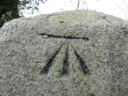
A double ditch at Derrinydaly near Trim. The bank up the middle and the ditch to the left and right of the central bank below the wire fencing are clearly visible. There is also hedging and trees on either side of the bank (photo by Conor Murphy)
Marie Cosgrave, project volunteer, points to the double ditch on her family farm at Newcastle, Enfield. There are beech trees on the banks. (photo by the Cosgrave family)

Benchmarks

An interesting feature that has been identified in many fields around the County is what is known as a Benchmark or Sapper’s Mark. This is a cut, chiselled into stone and resembles a crow’s foot shape. They can be seen on old stone buildings, gate posts, bridges, windowsills etc. These are old Ordnance Survey indications of altitude / elevation, the name derives from the angle iron which was fitted into the horizontal cut to give a ‘bench’ or support for a leveling staff. Contouring would usually begin from a bench mark. These were put in place in the 1800’s and many have stood the test of time very well, although as older buildings and structures deteriorate they are probably a feature that is in decline.

Close up view of the benchmark on a milestone at Syddan near Drumconrath (photo by Joan Mullen)
A Benchmark at the bottom of a stone gatepost at Derrinydaly near Trim (photo by Conor Murphy)

War References

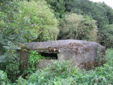
There are a significant number of references to World War I and World War II in the notes given about fields and their history. There are many references to crops grown during the Wars, mainly to wheat and flax.  There are also several references to trees and woods being cut down during this time.

A number of fields mention the ‘Pillbox’ feature. These were small reinforced concrete buildings constructed at river crossings and at other strategic points along the Boyne.   They are mentioned at the townlands of Fennor, Roughgrange and Oldbridge in returns for the Field Names Survey. There is also a prominent pillbox along the road on the south side of Stackallen Bridge (Broadbridge) across the Boyne.

Pillbox, dating from the Second World War, near Oldbridge (photo by Joan Mullen)

The Land Commission

The Land Commission is mentioned hundreds of times on survey returns from the Meath Field Names Project. Expressions like ‘Land divided by the Land Commission’ or ‘This farm was a Land Commission divide’ are used. The dates mentioned for these Land Commission divisions range from the 1930s to the 1970s. The work of the Land Commission has left an indelible mark on the Meath landscape and has shaped some of the pattern of Meath fields we see today. The houses and farm yards built for migrating families were in distinctive styles and are still very evident around rural Meath today. On the fields themselves a distinctive form of fencing was often used to divide fields. This fencing has stood the test of time and can still be seen around many fields. New lanes and roadways were constructed by the Land Commission in many areas. These were frequently cul de sacs and continue to be a feature in the Meath countryside today. It is very clear from the notes that the Land Commission division of fields had a significant impact on field names. Frequently we are told of a large field on a given Estate that had a field name before division that was subsequently lost.

Land Commission fence at Hayestown, Navan (photo by Joan Mullen)

A Walking World

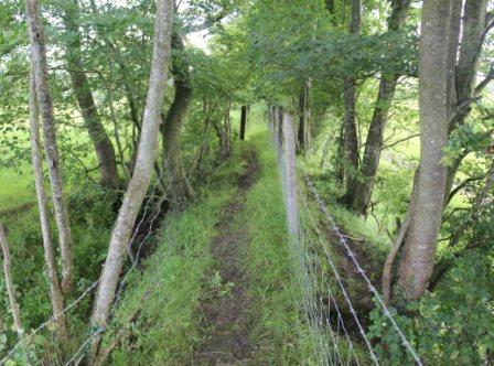
Before motorised transport people in the countryside went on foot or cycled where they needed to go. It was mainly a walking world. This was reflected in the shape and layout of the rural landscape. There were lanes, footpaths and stiles. Cross country routes that were taken as shortcuts when walking had wooden planks across ditches, drains and streams. There were many more small rural shops located much closer to each other than nowadays. This is another reflection of the ‘walking world’. The movement of cattle and sheep by foot on roads by cattle drovers was another key part of this walking world. Mass paths were used in Penal times but many continued to be used long after this time simply as the shortest route for people to walk to their local church. Country children would also have walked on shortcuts across fields to school. In the Schools Folklore Collection from the 1930s it is clear how knowledgeable the children were on the local fields and countryside. This knowledge was gained from their daily journeys to school and other places.
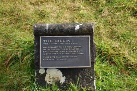
Stone stile through the stone wall going into a field at Rockfield, Julianstown near Drumconrath (photo by Joan Mullen)
Stile with clear stone steps built into the stone wall in a field at Boolies, Oldcastle (photo by David Sheridan).

Killeen

A Killeen (Cillín) is a burial place for unbaptised infants. These are sometimes located outside the walls of consecrated graveyards. There are often no stones or headstones to mark the graves and nothing visible to mark the site. In some areas Killeens were also burial sites for adults and not just infants. The presence of a Killeen in an area will usually only be known by local people and through local folklore. The Meath Field Names Project had a specific tick box on the field survey form for this feature and explained what the feature is in the volunteer helpguide booklet.  The Meath Field Names survey has found at least 8 references to ‘Kileens’ among the field returns.
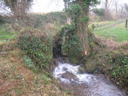
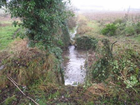
The Cillín stone at Killeen townland near Dunshaughlin. The inscription reads ‘The Cillín, 7th to 12th Centuries AD. Originally an agricultural settlement, the D shaped enclosure was reused as a children’s burial ground. This site may have given Killeen its name.’ Killeen(Cillín) is a burial place for unbaptised infants (photo by Frances Tallon)

Sheep Bath

A feature called a ‘Sheep Bath’ or a ‘Sheep Wash’ is mentioned in several fields. 

At Knockbrack (near Oldcastle) near the ‘Priest’s Wood’ we are told about a sheep bath with the following detailed description of how it worked – “There is a sheep bath located on the river in this field, also known locally as washing tub. It was used to wash sheep to clean the wool before they were shorn. The sheep bath was a man made construction built around the banks of a small river to wash the wool of the sheep before they were shorn. The construction consisted of two vertical sluice gates, one at the back to stop water entering the bath and the other 20 feet down to stop water leaving the bath. Before letting the sheep in the back gate was closed (lowered). The front gate was left open, when all the water escaped from the bath, the front gate was closed (lowered). The sheep were then escorted into the bath via a sloped side entrance. When inside the back gate was opened and raised to let the water fill the bath. Surplus water would flow over the front gate. The sheep would float about for ten minutes. The back gate would be closed and the front one partially opened allowing the water to escape and the sheep would walk out the side entrance. It works on the same principle as a lock on a canal.”

Many of these features are gone or no longer clearly visible. It would seem that many of these sheep baths or sheep washes were used to wash sheep before they were shorn so that the freshly shorn fleece would be as clean as possible. These baths were mainly constructed in rivers or streams. It was a lot of work to wash each sheep and then let the wool dry before shearing. Today sheep are not washed before shearing. The prices now paid for wool would never merit this level of effort.

Some of the references may be to the early versions of the modern type of ‘sheep dip’ where the sheep are immersed in a pit of water with additive to prevent blowfly hatching in their fleece. This is quite a different process than washing the sheep’s wool before shearing.

Old ‘Sheep Bath’ at ‘Pond Field’ Summerbank, Oldcastle viewed from one side (photo by Martin Devin)
Old ‘Sheep Bath’ at ‘Pond Field’ Summerbank, Oldcastle viewed from the opposite side (photo by Martin Devin)

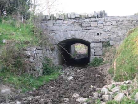
Victorian Cattle Underpass

At Athgaine Great (near Cortown, Kells) there is an underpass for livestock from Victorian times, linking two fields. This was an unusual feature in those times.  In modern times concrete cattle underpasses are sometimes built for farmers where their farm is split by new roads and motorways.

Victorian cattle underpass, at Athgaine Great, near Cortown, Kells. This was for livestock and linked two fields. This was an unusual feature in those times. In modern times concrete cattle underpasses are sometimes built for farmers where their farm is split by new roads and motorways (photo by Eamonn Courtney)

Other

On the project survey form there were tickboxes for other archaeological features such as Rock Art, Standing Stones, Tombs, and Souterrains. Rock art is mentioned in six townlands  [Ballinvally (Oldcastle), Corrakeeran, (Kilmainhamwood), Croboy (Hill of Down), Muff (Nobber), Nevinstown (Navan), and Teltown (Donaghpatrick)].

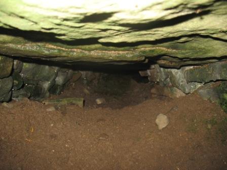
Fifty seven fields mention souterrains or underground systems; some of these fields have names like ‘Cave Hill’. Standing stones are indicated in 60 fields. Tombs are mentioned in over 30 fields.

Entrance to souterrain at Shankill, Summerbank, Oldcastle (photo by Martin Devin)
View looking into the souterrain at Shankill, Summerbank, Oldcastle (photo by Martin Devin)

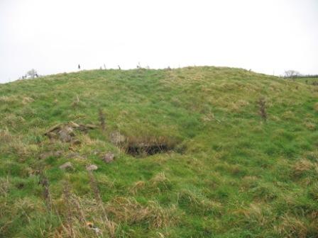
At the end of this section there was a general tickbox to indicate any other man made feature present in the field not indicated on the survey form. It was hoped that features not already known on the Archaeological Survey of Ireland would come to light. This threw up a whole range of features in fields. These included castle and church ruins, old graveyards, stone arches, síle na gig sculptures, fulacht fiadhs, coach roads, pigeon houses, dovecotes, footpaths, tumuli, dolmens, turnpike roads, old bridges and motte and bailey features.   Five townlands have fields that indicate the presence of a Crannóg. They are Brittas, Whitewood and Nobber townlands all in the Nobber area, Rathkenny (Slane) and Grangend Common (Dunshaughlin).


Of course fields have been identified with many more modern features. These include features such as air strips, electricity pylons, gas pipelines, mushroom tunnels, motorways and modern horse gallops.

Oliver and Karen Ward, Nobber at the launch of the book ‘The Field Names of County Meath’. Oliver is secretary of the Steering Group of Meath Field Names Project (photo by Kieran Cummins).
Joan Mullen, Project Co-ordinator; Eamonn Courtney, Cortown; Willie Hodgins, Bohermeen and Dr. Nollaig Ó’Muraíle, NUI Galway at the launch of the book ‘The Field Names of County Meath’. Dr. Nollaig Ó’Muraíle, an Irish place names expert assisted the group with translations of Irish field names.
Matt Dempsey, Irish Farmers Journal speaking at the launch of the book ‘The Field Names of County Meath’ (photo by Kieran Cummins).
Karen Carty and Terry Foley both from Anú Design, Tara and Henry O’Callaghan, Dunderry at the launch of the book ‘The Field Names of County Meath’. Anú Design did all the graphic design on the book.
Eddie Downey, Deputy President of the IFA speaking at the launch of the book ‘The Field Names of County Meath’(photo by Kieran Cummins).
John McCullen, Beamore, Chairman Meath Field Names Project speaking at the launch of the book ‘The Field Names of County Meath’(photo by Kieran Cummins).
Joan Mullen, Project Co-ordinator Meath Field Names Project and Noel French, Meath Heritage Centre at the launch of the book ‘The Field Names of County Meath’ (photo by Kieran Cummins).
Tom Hennessy, Chairman Meath Partnership speaking at the launch of the book ‘The Field Names of County Meath’. Meath Partnership gave financial support to the project through the Leader Rural Development Programme (photo by Kieran Cummins).

Buzzing atmosphere at the book launch of ‘The Field Names of County Meath’ 

There was a great buzz of excitement last Thursday night for the launch of the book ‘The Field Names of County Meath’. Over 300 people attended the event at the Ardboyne Hotel, Navan; many of them had been directly involved in contributing to the project.


As people arrived many of them purchased their copy of the book and then keenly thumbed through the pages to find mentions and photos of their own fields and townlands. The event was a celebration of a lot of hard work, all coming together into a worthwhile end product.

Speakers on the night were John McCullen, Project Chairman; Ciarán Mangan, County Librarian; Tom Hennessy, Chairman Meath Partnership; Eddie Downey, Deputy President of the IFA and John Clancy, President of Meath Archaeological and Historical Society.


The book was launched by Matt Dempsey, from the Irish Farmers Journal.

A theme touched on by all the speakers was the huge contribution that volunteers and voluntary work made to this project. Individual speakers also highlighted aspects of the book that particularly appealed to them such as the photos of forge made gates, the examples of unusual field names and the preservation of farming memories from days gone by.


John McCullen explained how the book is laid out with information on the origins of the project, the project findings, volunteer experiences of doing survey work, a variety of townland maps, articles by contributors with specialist expertise and a sizable selection of photographs.


The book has over 400 pages in full colour. At this size it is not intended that a reader will read it from cover to cover in one sitting. It is a book that the reader can dip in and out of and refer back to. Great time and effort has gone into preparing this book to ensure a top quality publication. Frances Tallon of Meath County Council Library Service was the main editor of the book. In keeping with the ethos of the Steering Group to support local enterprise, the graphic design work was done by Anú Design, Tara. Great praise is due to Karen Carty and Terry Foley for their meticulous design work. The book was printed by Anglo Printers in Drogheda, also a very professional job.

The group hopes that the book strikes a good blend and balance; and indeed that it will lead to readers appreciating Meath fields and their names in a whole new light. The book has been very well received to date. It has been described as ‘a beauty that will be treasured in many’s the home.’ Hundreds of photos of Meath fields and interesting features in those fields are distributed throughout the book. Many people were involved in taking this beautiful and well observed photos, each photographer is credited.


Hundreds of volunteers around the County have helped with this project and many of them attended the book launch to see results of their work. Voluntary work was the foundation of this project. It could not have happened without the hundreds of helpers who gathered the field names and contributed in so many ways to the success of the project. This book launch marks the culmination of over three years of voluntary work. One Dublin person who attended the launch commented that the project ‘demonstrates the importance of grassroots in every sense.’


Meath Field Names Project was developed and managed by a committed voluntary steering group chaired by John McCullen. Project secretary Oliver Ward has given the project a huge commitment from the early days. The book has been compiled by Joan Mullen, Project Co-ordinator. The Steering Group has 18 members from all around the County.


The principal project funder has been Meath Partnership through the Leader Rural Development Programme. The FBD Trust was the main benefactor of the project and gave generous matching funding in the early stages of the project making it possible to proceed with Leader applications. The project has also received financial support from the Heritage Council and a range of Meath contributors. The three partner organisations in the project are Meath County Council Library Service, Meath IFA and Meath Archaeological and Historical Society.

The Meath Field Names Project is the first of its kind for an entire County in Ireland. As such it is breaking new ground. There are records for just over 24,700 fields on the database – no small achievement! There are still townlands in Meath where the field names have not been gathered and surveyed. If more resources become available in the future it may be possible to complete the work. People interested in surveying townlands not already covered are invited to contact the project through the website. It is hoped that the project will be replicated in other Counties, several are already showing interest.


The first part of the project website is now live at www.meathfieldnames.com. An interactive mapping feature will be added to the website in the next 2 months that will enable the browser to look at field names in all townlands surveyed and drill down into all the information within the project database.

The book will be of great interest to many people including Meath people living abroad. It is now available to buy for €20 at all branches of Meath library. It will also be available in some local shops and through members of the project Steering Group. For more detailed information on outlets stocking the book check the news section of the website www.meathfieldnames.com. For people outside County Meath interested in obtaining a copy of the book, it is available to order online through www.kennys.ie.

Our book is available on sale at:

– www.kennys.ie for people outside Meath and abroad

– From Sep. 2014 the book is also available from a second online seller – www.farmersjournal.com/store

– All branches of Meath Library [Navan, Ashbourne, Athboy, Duleek, Dunboyne, Dunshaughlin, Kells, Nobber, Oldcastle, Rathcairn, Slane & Trim].

– For Christmas 2014 Hodges Figgis in Dawson St., Dublin will carry a small stock of the book.

– Maguire’s Gift Shop at the Hill of Tara

– Tierney’s Newsagents, Trimgate St, Navan

– Antonia’s Bookstore, Navangate St, Trim 

– Alfco Agri Store, Newtown, Trim (no longer stocking from Nov. 2014)

– Royal Town & Country Stores, Ardbraccan, Kilmessan (out of stock Nov. 2014)

– Royal County Agri Services, Academy St, Navan

– Oliver Usher’s Auction Rooms, Kells

– McAuley’s Grassmeal Office, Balrath, Kentstown

– Brú na Bóinne / Newgrange Visitor Centre Gift Shop

– Loughcrew Gardens, Oldcastle

– Kraft Kaffe, Oldcastle

– Oldcastle Co-op

– McQuaid’s Pharmacy, Oldcastle 

– Slane Farm Supplies, Collon Road, Slane

– Easons, Navan

– Brian O’Donoghue’s Barbers, Enfield

– Sage and Stone, Duleek

– Tara News Newsagents, Dunshaughlin (none in stock as of Nov. 2014)

– NUI Maynooth Bookshop on University Campus

– Maynooth Books, Main St, Maynooth

– Millmount Museum, Millmount, Drogheda

– ABC Books, 12 West St, Drogheda

– R.B. Daly’s Auctioneers, Laurence St, Drogheda

– Waterstone’s, Scotch Hall, Drogheda

– John’s Centra, Platin Rd, Drogheda

– Ardee Bookshop, Ardee, Co. Louth

– An Grianán, Termonfeckin, Co. Louth

– Fore Coffee Shop, Fore, Co. Westmeath

– From Steering Group members (see ‘About us’ section on site for list)

– On www.kennys.ie for people outside Meath and abroad.

There has been some technical difficulty on the kennys website recently.  If the book is not coming up please e-mail desi@kennys.ie or phone 091-709367 and Des Kenny will assist you.

– From Sep. 2014 the book is also available from a second online seller –  www.farmersjournal.com/store


– The title of the book is ‘The Field Names of County Meath’

  The recommended retail price is €20

We update this list of our stockists regularly.

The first stage of the website for Meath Field Names Project went live in mid February.  Over the coming months we will be enhancing and improving this site. We plan to embed an interactive mapping section into the site. A browser will start with a map of Meath; they will be able to zoom in on the part of the County they are interested in. They can then zoom in on their chosen townland. At this point the field names will appear on the fields within the townland. It will be possible for the browser to click on any individual field and the details gathered about that field (history, features, folklore etc) will pop up.  We are working on this at present.

We will officially launch this website shortly after our book publication in July / August of this year.  We would appreciate if any local history and Meath related sites could create links through to our site.


Meath Field Names Project Steering Group has pleasure in inviting all interested people to the launch of the book

‘The Field Names of County Meath’

at the Ardboyne Hotel, Navan

on Thursday 27th June at 7.30 p.m.

The book will be launched by

Mr. Matt Dempsey, Irish Farmers Journal

Book Launch – ‘The Field Names of County Meath’ – Pre launch press piece

The Steering Group of Meath Field Names Project that has been working away for the last few years on gathering the field names of County Meath, their history and their lore has announced that the launch of the much anticipated book ‘The Field Names of County Meath’ will take place on Thursday 27th June at 7.30 p.m. in the Ardboyne Hotel, Navan. The book will be launched by Matt Dempsey from the Irish Farmers Journal.


Information on the origins of the project, the project findings, volunteer experiences of doing survey work, a variety of townland maps, articles by contributors with specialist expertise and a vast range of photographs of Meath are all presented in this publication. The book has over 400 pages in full colour. Great time and effort has gone into preparing this book to ensure a top quality publication. ‘The Field Names of County Meath’ will be a valuable addition to Meath’s local history publications. The group hopes that the book strikes a good blend and balance; and indeed that it will lead to readers appreciating Meath fields and their names in a whole new light. The hundreds of photos in the book have been contributed by many photographers, both amateur and professional. They greatly enrich the book and draw attention to many unusual features that are unfortunately in decline.


Hundreds of volunteers around the County have helped with this project and many of them will be at the book launch to see the fruits of their labour. Voluntary work was the foundation of this project. It could not have happened without the hundreds of helpers who gathered the field names and contributed in so many ways to the success of the project. Volunteers found the work in gathering Field Names to be sociable and enjoyable. The interest in local history around the County is amazing and we are fortunate to have such a rich heritage. Landowners and farmers love to talk about their fields, they appreciate very much that the ‘old’ field names have been recorded. This book launch marks the culmination of over three years of voluntary work.


Meath Field Names Project was developed and managed by a committed voluntary steering group chaired by John McCullen. Project secretary Oliver Ward has given the project a huge commitment from the early days. The book has been compiled by Joan Mullen, Project Co-ordinator and edited by Frances Tallon of Meath County Council Library Service. The principal project funder has been Meath Partnership through the Leader Rural Development Programme. The FBD Trust was the main benefactor of the project and gave generous matching funding in the early stages of the project making it possible to proceed with Leader applications. The project has also received financial support from the Heritage Council and a range of Meath contributors. The three partner organisations in the project are Meath County Council Library Service, Meath IFA and Meath Archaeological and Historical Society.


The Meath Field Names Project is the first of its kind for an entire County in Ireland. As such it is breaking new ground. County Meath has a little over 1,600 townlands. It is a vast area. As some townlands are totally urban and are within towns and villages they were outside the remit of this project. The Meath Field Names Project estimated that 1,400 townlands was its target area. Approximately 850 townlands in Meath have been surveyed by the Meath Field Names Project (making a return of 60% of the 1,400 estimated rural townlands in Meath). There are records for just over 24,700 fields on the database – no mean feat!


Most of these 850 townlands have been fully surveyed. However, there is a percentage of these 850 townlands not fully complete. Of course, this does mean that 40% of the rural townlands in Meath have not been surveyed. If more resources become available in the future it may be possible to complete the work.


The first part of the project website is now live at www.meathfieldnames.com. The project is working on a ‘plug in’ section that will be added to this website. This will enable a person to browse a map of Meath, zoom in on a chosen area, then on a chosen townland. The plan is that when the browser zooms in close the field names will appear on the fields. A browser will then be able to click on the field name and all the other information gathered about the field and stored in the database will come up. Mallon Technology, a company based in Cookstown, Co. Tyrone is assisting the project in completing this work and it will be finalised in the next month or two.


Interested people are most welcome to attend the book launch on Thursday 27th. Copies of the book will be on sale on the night and afterwards at local branches of Meath Library and through steering group members. There will be a special launch price of €15 per book on the launch night, thereafter the book will be sold for €20. For people outside County Meath interested in obtaining a copy of the book, it will be made available through an online supplier, details will be posted on the project website shortly.

For further information contact Joan Mullen, Project Co-ordinator on 087-2077622